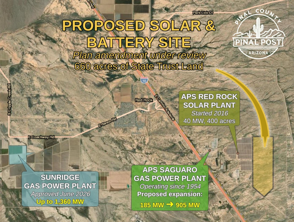
RED ROCK, AZ — Pinal County is reviewing a request to allow a utility-scale solar farm and battery storage facility near Red Rock. The site covers about 660 acres of state trust land roughly three miles southeast of the community. It adjoins the existing APS Red Rock Solar Plant. The APS Saguaro gas plant, which APS proposes to expand by about 720 megawatts, lies farther west. On the other side of Red Rock, supervisors in June approved a county industrial use permit for the up-to-1,360-megawatt Sunridge Power gas plant to the southwest. If both gas projects are fully built as proposed, they could add up to 2,080 megawatts of gas-fired generating capacity in the Red Rock area. That would be in addition to about 225 megawatts of existing capacity at the APS solar and gas plants. The state land project would add solar generating capacity and battery storage, but neither size has been announced.
County planners presented the Red Rock solar and battery project at two work sessions. The Planning and Zoning Commission heard it on Aug. 20, and the Board of Supervisors heard it on Sept. 2. Neither body voted, and staff gave no construction timeline. The closest homes sit about a half mile east of the site.
The applicant, LSH Land Holdings, LLC, is asking the county for a major amendment to its long-range land use plan. Currently, the county’s 2019 comprehensive plan designates most of the land for employment and the rest for housing at one to 3.5 homes per acre. The applicant wants it relabeled Green Energy Production, the county’s designation for solar development. Jennifer Dean of 39 North, LLC, represents the company, and the Arizona State Land Department owns the land.
Supervisor Stephen Miller remarked on that change at the Sept. 2 session. “I think it’s so interesting that all of a sudden we’re shifting our direction from one to 3.5 dwelling units to the acre to energy production, and it’s just something that’s changed,” he said.
A square mile of state land east of Interstate 10
The site is slightly larger than one square mile. It lies east of Interstate 10, south of Mona Road, north of South Dozer Road and west of South Marylynne Lane.
Senior Planner Valentyn Panchenko said nearby power generation and transmission lines drove the choice of location.
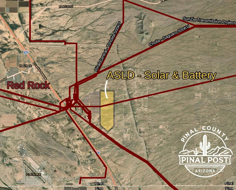
Planning Supervisor Sangeeta Deokar told supervisors the applicant hopes to use existing high-voltage lines that already serve the APS solar station.
Homes a half mile east and a buffer with no guarantee
Between the nearest homes and the proposed 660-acre solar and battery site lies a strip of state land that is not part of this request.
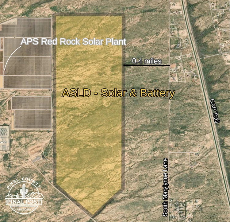
The strip of state land separating the proposed site from the homes to its east will keep its residential label for now. However, Panchenko said there is no guarantee it stays undeveloped, because its current General Rural zoning does not set it aside as a buffer and leaves it open to development in the future. It acts as a buffer today only because it remains vacant, he said, not because it is a formal buffer.
Chairman questions 600-foot notification radius
Board Chairman Jeff McClure raised the county’s notification rules at the Sept. 2 session. Only three landowners fall within the county’s 600-foot formal-hearing notification radius: the State Land Department, APS and Pinal County. McClure said the 600-foot line does not even reach the homes whose owners had already reached out about the project. He asked why the county does not push the line out to 1,200 feet so that notices reach nearby homes. Otherwise, he said, it is “kind of a useless notification.”
Deokar responded that the county uses 1,200 feet for neighborhood meetings, which the applicant is expected to hold. The 600-foot radius applies when a proposal comes before the commission and board. In addition, Panchenko told commissioners the applicant has added residents east of the project to its notification list. The county also asked for broadcast signs along nearby streets.
Miller was the only other supervisor to comment on the proposal. Meanwhile, at the commission’s Aug. 20 meeting, Chairman Robert Klob asked for questions on the proposal, and the record shows none.
Staff have advised APS in case it expands solar next door
Panchenko described the proposal as an extension of the solar development already on the neighboring APS land. However, this request covers only the 660 acres of state trust land, not the APS property. He said staff have advised APS to change the designation on its existing solar plant from Employment to Green Energy Production, the same change this request seeks. That would keep the plant in line with the plan if APS ever expands solar north or east of it. However, whether APS does so is up to APS, and the county does not know its plans.
Washes and floodplain cross the site
Washes run east to west across the property, and the county’s Open Space Department identified riparian, or streamside, habitat along them. The department will require a 50-foot buffer along major washes and that habitat. Additionally, the county has received a wildlife report from the Arizona Game and Fish Department. Deokar said staff are reviewing it and plan to build some of its conditions into the project.
Parts of the site also lie in FEMA-mapped floodplain, including areas where floodwater is expected to reach about a foot deep. Panchenko attributed that to the upper Santa Cruz River watershed. As a result, the applicant must complete a drainage study before construction.
Red Rock solar and battery project adjoins a 400-acre APS plant
The existing APS Red Rock Solar Plant began operating in December 2016. It covers about 400 acres and has a capacity of 40 megawatts. McCarthy Building Companies built it, and according to the company it was the largest APS solar facility at the time. It connects to the grid at a nearby APS substation.
For a rough comparison with a newer project, the 2016 APS Red Rock Solar Plant uses about 10 acres of land for each megawatt it can produce. The Eloy Valley Energy Center III, a solar and battery project south of Eloy that supervisors approved in September, plans about three acres per megawatt. The comparison is rough, since the two projects may count land and capacity differently and Eloy’s plans could still change. The proposed state land project cannot yet be compared because its capacity has not been announced.
Arizona State University buys 65,000 megawatt-hours a year from the APS Red Rock Solar Plant under a 20-year agreement, according to the university’s project page.
APS also plans a 720-megawatt gas expansion at Saguaro
The neighboring APS Saguaro Power Plant has operated in Pinal County since 1954. It now runs three natural gas turbines with a combined capacity of about 185 megawatts, according to U.S. Energy Information Administration data. The proposed expansion would bring the site to roughly 900 megawatts. APS has begun the permitting process to add two natural gas units at the site, according to the utility’s Saguaro expansion page. Each simple-cycle unit could add about 360 megawatts, or roughly 720 megawatts in total.
APS chose Saguaro to make use of infrastructure already in place, including transmission capacity. APS says the expansion would serve existing customers and normal growth, not data centers. If approved, construction could begin in 2028, and APS expects the units to be in service by 2030.
Details on the expansion’s permitting and public comment process are on the utility’s Saguaro expansion page.
Plan amendment and rezoning still ahead for the solar site
The county has not yet approved the state land solar and battery project or the comprehensive plan amendment it needs; both meetings were informational. Changing the 660 acres to Green Energy Production is the first step. If the county approves that amendment, the applicant must then apply for rezoning, which requires separate approval. Neither meeting set a date for a formal hearing or vote on the amendment.
Case number: PZ-PA-014-26