Key points
- The county Planning and Zoning Commission voted 5-3 to recommend redesignating 660 acres of State Trust Land west of Marylynne Lane from Employment and residential uses to Green Energy Production.
- Longroad Energy plans 80 megawatts of solar panels and batteries rated at 80 megawatts beside the existing APS Red Rock Solar plant.
- The county’s Citizens Advisory Committee recommended denial, and residents raised concerns about fire, flooding, heat, dust and their single road out.
- The vote changes only the land-use map; a rezoning and site plan approvals must follow before construction.
- The Board of Supervisors was scheduled to consider the case Nov. 18.
RED ROCK, AZ — A 660-acre field of solar panels and batteries moved one step closer to the State Trust Land west of Marylynne Lane on Oct. 15, when the Pinal County Planning and Zoning Commission voted 5-3 to recommend approval of the Red Rock solar project. The recommendation contrasts with that of the county’s Citizens Advisory Committee, which voted unanimously against it. However, nothing gets built yet: the commission acted only on a land-use map change, and the developer must still win a rezoning and other approvals before construction can begin.
This case is a comprehensive plan amendment, which changes only the land-use designation on the county’s long-range map; the commission recommends and the Board of Supervisors decides. A separate rezoning would follow, with its own public hearings before both bodies. Chairman Robert Klob told residents the rezoning is where stipulations can address their concerns, calling it “a much better place where we have a lot more control.” This vote, he said, “just allows them to start down that path.”
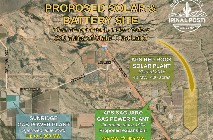
The proposed solar and battery project on state trust land near Red Rock, shown with other energy, data center and infrastructure projects in the area. Zoom and pan to explore, and click any colored area for a description. (Map: Pinal Post) · Open the map full-screen
Red Rock Solar Project Site and Surrounding Zoning
The application would redesignate roughly 472 acres of Employment land and 188 acres of Moderate Low Density Residential to Green Energy Production. Existing zoning on the site is a mix of CI-1 light industry, CI-2 industrial and General Rural, with about 396 acres zoned industrial. CI-2 permits some of the county’s heaviest uses, including slaughterhouses and petroleum refineries with a permit. As a result, Carolyn Oberholtzer, an attorney representing Longroad Energy, argued that the green-energy designation “secures this reduction in intensity” for neighbors.
Arizona Public Service operates two separate power plants just west of the site. Its 40-megawatt Red Rock Solar facility, which also has batteries, sits immediately next door. Beyond it is the Saguaro Power Plant, a natural gas plant operating since 1954, which APS has proposed expanding with two new units adding about 720 megawatts. Nearby are the Saguaro 500-kilovolt substation, an APS substation and the Tortolita substation operated by Tucson Electric Power. Longroad Energy’s project would connect to the Tortolita substation through a generation-tie line of roughly 0.4 miles, entirely on state land. An existing APS high-voltage transmission line already crosses the site.
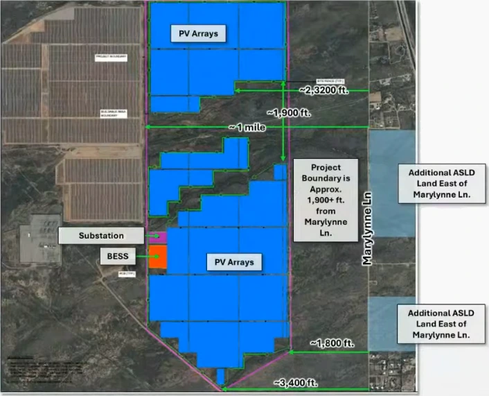
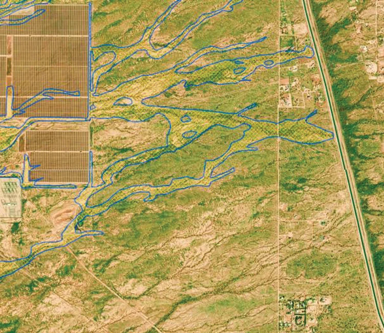
Homes are concentrated east of Marylynne Lane, where residents have Marana mailing addresses. The application places the closest residence “approximately 1,910 feet from the Project boundary,” with State Trust Land that is not part of the application in between. Resident Ioan Sagau counted 58 houses east of Marylynne Lane, plus 79 undeveloped parcels. Additionally, the applicant’s concept plan runs panels to within about 1,800 to 1,900 feet of Marylynne Lane along most of the site’s east edge, stepping back to more than 2,300 feet near the northern group of homes, and leaves open what Oberholtzer called “a very significant drainage corridor” through the site.
80 Megawatts of Solar Paired With 80 Megawatts of Batteries
Oberholtzer told commissioners the facility is sized at 80 megawatts of solar generation plus batteries rated at 80 megawatts. The battery figure is a power rating — how fast the system can deliver electricity — not how much energy it stores; no megawatt-hour capacity was given, and the staff report says battery size and chemistry are not yet fixed. Oberholtzer said Longroad Energy needs about 80 megawatts for a project to be viable, and the 660 acres reflects what is needed to reach that output. Panels would stand about 12 feet tall at full tilt.
Meanwhile, the battery field is expected to cover about 20 acres on the far west side of the site, next to an internal substation. The units are self-contained, container-like enclosures roughly 10 to 13 feet high. Once operating, the project would employ up to five workers. Oberholtzer said ASLD solar leases typically run 30 years, though many projects plan to operate for 40.
From 1,280 Acres to 660: The Map Behind the Petition
The petition against the project began with a different map. In 2025, the Arizona State Land Department notified neighbors of an application covering about 1,280 acres that ran all the way to Marylynne Road. The current application is 660 acres, a 48 percent reduction that pulls the boundary back from the road. However, a petition circulated using the older map. Oberholtzer said it was presented to the Citizens Advisory Committee during its hearing as representing more than 200 opposing property owners. Because her team could not see the petition before or during that hearing, she said, she could not point out the smaller boundary, and the old map contributed to the committee’s opposition. The committee voted 0-14 to recommend denial, citing heat island effects, water use, proximity to homes, environmental impacts, fire safety, property values and visual impacts.
By the October hearing, staff had counted 34 opposition letters and a petition with 87 signatures. In response, Marylynne-area resident Patrice Lewis told commissioners the petition now carries 241 signatures, not the 17 cited in earlier county materials. Gail Higashi, a Marylynne Lane resident, added that she signed under the old map and would sign again under the new one. Earlier outreach included a May 13 neighborhood meeting at Red Rock Elementary School, which drew nine members of the public along with Board of Supervisors Chairman Jeffrey McClure.
Trains, Fire Response and Flooding Lead Safety Concerns
Kevin Higashi, a 14-year ranch owner on Marylynne Lane, told commissioners the community effectively has one way in and out. Missile Base Road led to a now-decommissioned missile silo and was limited to one access for security reasons, he said, and the community has since grown up around it. Trains frequently block its crossing. The alternatives are a 25-mile trek north to the frontage road or about 12 miles of mostly dirt roads south, including 2.5 miles of state-land trails. He added that the fire station inside the neighborhood is staffed by only two people, and homes rely on wells with no hydrants. He also cited Electric Power Research Institute data on U.S. battery-storage fires, including a 2025 incident in Peoria and a 13-day fire in Chandler in 2022.
Ioan Sagau said a fire at the project’s south end could block the only exit while running washes cut off the rest, since floodwater passes under the canal even when local skies are dry. Rachael Sagau, a mother on Marylynne Lane, asked commissioners whether they would accept the fire risk across the street from their own families. County standards require the project to have two permanent, paved access points. Longroad Energy is evaluating a second route through APS land. At the May neighborhood meeting, residents asked about a new railroad crossing, but Supervisors Chairman McClure said one would be extremely hard to get.
Kevin Higashi also said the adjacent APS solar field was graded above the surrounding land with trenches draining south, and the Missile Base Road and frontage road intersection has since flooded badly — once with a 90-minute wait for water to recede. In response, Vice Chair Karen Mooney asked staff to investigate the runoff reports; Planning Manager Harvey Krauss said it was the first he had heard of them.
Avra Valley Fire District Chief Brian Delfs spoke in support. He praised Longroad’s work on its nearby Serrano project, said the company had already provided an emergency plan and access routes for this facility, and said it has offered direct assistance to buy unfunded equipment. The project would also improve access to the back side of the APS plant, he said, and added property-tax revenue might let the district reduce property taxes across a community of about 12,000 residents. The district issued a will-serve letter and has stations on both sides of the railroad tracks.
Creosote, Caracaras and a Desert “Pulsating With Life”
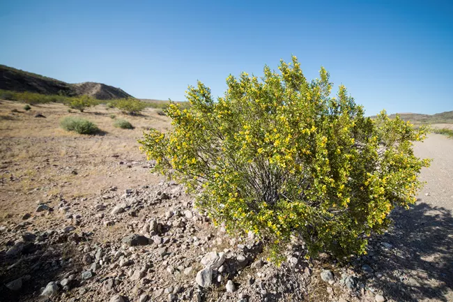
Kim Hobbs, who lives directly across from the site, told commissioners that scraped desert cannot simply be restored. Creosote grows a third of an inch a year, she said, and its interconnected root systems hold down dirt in a high-wind area; removing it would unleash dust. She described two crested caracaras living along Marylynne Lane, desert iguanas, and venomous snakes that she expects construction would push onto neighboring properties. “Why are we putting solar on living desert?” she asked, suggesting panels over the adjacent CAP canal or parking lots instead and calling the desert “pulsating with life.”


Opposition letters added concerns about construction dust spreading Valley fever, herbicide use, erosion, noise and wells running dry. A 10-year-old Marylynne Lane resident told commissioners he hikes the state land with his family under a recreation permit, finding shells and animal bones, and does not want panels filling his second-story window view. Separately, Ioan Sagau pointed to the constant hum of equipment and said neither the existing homes nor the vacant parcels would sell with panels next door.
Theresa Gredig, a 28-year resident east of the canal whose two-story home sits upslope, said glare from the existing APS solar field and Marana-area arrays already cuts a “glaring white line” across views she photographs daily from five miles away. She also flagged earth fissures in the area, sheet flows redirected by regrading, and the cumulative weight of nearby proposals — the Sunridge gas plant, the Saguaro expansion, the Verdin solar project, solar fields in Marana and other energy projects in Eloy. “It’s similar to Hidden Valley. A lot of proposals, a lot of energy, and I want to know, is it all really needed?” she asked. Opposition letters echoed that theme; one pointed officials to the Pinal Post’s earlier reporting on the county’s data-center rush. Several writers suspected the power is destined for data centers; the development team has said the project stands alone and is anticipated to serve Tucson Electric Power customers and the broader grid.
Rooftop Views and the 15-Foot Flag Test
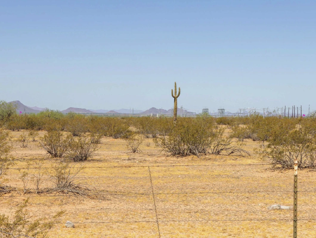
Commissioner Terrilyn Klucar asked whether east-side homes, which sit slightly higher, would look down on the panels. Oberholtzer answered with a flag test: the team flew 15-foot flags at the project boundary — three feet above maximum panel height — and photographed them from the closest points west of Marylynne Lane. The flags were barely visible, she said, and the existing APS panels cannot be seen from there at all. Still, she acknowledged that residents who climb onto their roofs to look west can see solar panels. Lewis confirmed she does exactly that, calling her clear view of APS equipment “not a pretty sight.” Ioan Sagau said: “Put panels in that line of sight, and you turn a sunset into a warehouse.” For her part, Oberholtzer cautioned that the vacant state land between the homes and the project should not be assumed to stay empty, given the area’s closeness to I-10.
The Heat Question, a Columbia Study and a Test Site Next Door
Oberholtzer cited a Columbia University study of the same module technology Longroad Energy uses, saying it found warming dissipates within about 1,000 feet of a project’s perimeter, with panels cooling at night and no sustained heat island. She added that vegetation density strongly shapes any heat effect and that revegetation can mitigate it. She also said monitoring around 12,000 acres of solar in western Maricopa County shows no perceptible temperature difference between project boundaries and residential boundaries, and that comparable studies of shopping centers and parking lots are lacking.
Commissioners questioned the study. Mooney noted it was done somewhere in North America, not necessarily Arizona, and doubted that panels cool at night where summer nights stay hot. She asked for seasonal baseline temperature readings on the vacant land for a full year before construction. Klob suggested that work could begin now at the APS solar facility next door — measuring from the center of the array, at the property line, and outward in 100- to 200-foot increments.
Commissioner Tom Scott of Coolidge — where he said 16 percent of the city’s limits went to solar before residents petitioned to stop it — said the Columbia study “might be accurate at a given place at a given time, but it’s not accurate here.” Temperatures at ground level beside panels there run 7 to 10 degrees higher, he said, and an aerial-applicator friend avoids flying over arrays in daytime because the thin, hot air costs planes lift. He added that an ASU researcher found a 1-to-3-degree increase but collected no data before construction — “the piece of the puzzle that’s missing” — and said he felt the applicant minimized residents’ comments. Lewis noted the neighborhood sits in a mountain-ringed valley that traps heat. Oberholtzer agreed with Klob that readings could be taken next to the APS site without entering it, said baseline readings could be taken in the zoning phase, and said she would keep the request in mind for her other Pinal County solar cases.
Not Public Land, but Land the Public Uses
The status of the land itself became a point of dispute. State Trust Land is not public land, Oberholtzer explained: the federal government granted it at statehood, and the Arizona State Land Department must manage it to maximize revenue for 13 beneficiaries, the largest being K-12 education; by the department’s own description, every use of the land must compensate them. The project is a lease, not a sale — one that must still be awarded at a state land auction — so the ground remains trust land. Revenue from this parcel would go to two beneficiaries, according to the application: the Normal Schools fund, which the state treasurer identifies as Arizona State University and Northern Arizona University, and the State Charitable, Penal and Reformatory Institutions fund, listed by the treasurer as supporting the Pioneers’ Home, corrections and youth treatment. Separately, Longroad Energy’s eight existing ASLD solar leases, nearly 12,000 acres, will pay more than $300 million to public schools, its presentation said.
Gail Higashi responded that the land is available to the public for uses such as horseback riding, off-road vehicles, hunting, birdwatching and hiking, and that her household bought the state’s recreation permits to use it. It also generates trust revenue through a current cattle-grazing lease, she said, and the project would eliminate residents’ access. She cited the Rosebud project heard earlier that day as an example of where such a facility should go: fully industrial-zoned private land more than a mile from homes.
Hauled Water and a Decommissioning Bond
On water, the applicant projects less than 100 acre-feet per year during one to two years of construction dust control, and under 20 acre-feet per year during operations for occasional panel washing and a restroom. No wells would be drilled and no groundwater pumped on site; water would be hauled in, with a storage tank kept for fire response. Scott pressed the point that hauled water still comes out of someone’s aquifer, on land that uses none today. Oberholtzer agreed the water comes from somewhere, but said it is purchased from a water company’s existing portfolio.
Decommissioning drew questions as well. ASLD leases require a full decommissioning and reclamation plan backed by a financial assurance bond posted before construction, with third-party cost reviews; the county adds its own requirements through zoning stipulations for the life of the project. Disturbed areas must be revegetated with native species, and Oberholtzer said saguaros and other protected plants would be kept in place or relocated where possible, following Game and Fish protocols. Commissioner Gary Pranzo, citing his own decommissioning experience, called writing such plans 20 to 30 years in advance “a waste of time and money.” Oberholtzer responded that the plans evolve with technology under county and state oversight. Perimeter fencing would likely be slatted chain link, raised off the ground for wildlife passage and positioned to catch dust.
Record Demand, and Why the Site Wasn’t Moved North
Oberholtzer said Arizona utilities hit record peak demand this summer and want generation that can connect quickly; pairing solar with batteries banks daytime power for evening use. Asked why the project could not shift north, away from homes, she said that would push it into more floodplain and wildlife-movement areas and require longer new transmission lines. Commissioner Bryan Hartman cited similar reasoning when he moved for approval, saying the existing APS infrastructure makes the location right and the project deserves to move forward into zoning review.
Red Rock Solar Project Goes Before Supervisors
The roll call split the commission: Klob, Hartman, Albert Lizarraga, Daren Schnepf and Pranzo voted yes; Mooney, Scott and Klucar voted no. The recommendation was forwarded without stipulations, because conditions cannot attach at the plan-amendment stage. If supervisors approve, Longroad told the commission it expected to file its rezoning and planned area development package by the end of 2026 — the stage where setbacks, fencing, drainage design, fire standards and the temperature studies commissioners requested can become enforceable conditions.
Case numbers: PZ-PA-014-26 (Major Comprehensive Plan Amendment); county pre-application Z-PA-045-26.