Pinal Post

Independent Local News for Pinal County, Arizona

Support Local Journalism
Advertise With Us
  • Home
    • Apache Junction
    • Casa Grande
    • Coolidge
    • Florence
    • Maricopa
    • STV
  • Community
  • Government
  • Safety
  • About
Search
  • Home
  • Agriculture
  • Cattle

News

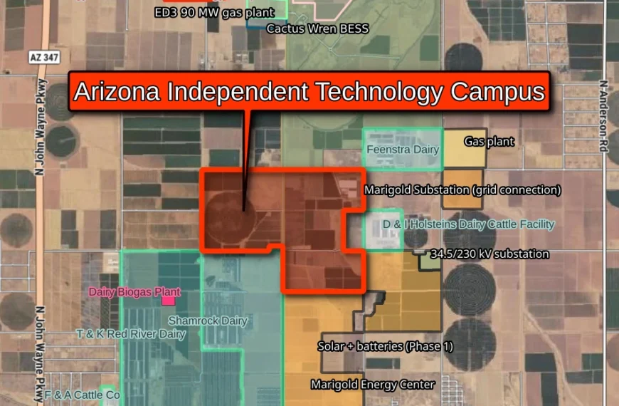
Aerial map of farmland south of Maricopa showing the Arizona Independent Technology Campus outlined in red. Dairies surround it, including Shamrock Dairy, T&K Red River Dairy, Feenstra Dairy and D&I Holsteins, with SRP’s Marigold Energy Center solar, battery and substation sites to the south and east and a gas plant to the northeast. The Energy Generation and Technology Campus, a 90-megawatt gas plant, a battery storage site and the Rosebud Energy Project lie to the north, between Highway 347 and State Route 84.
AgricultureCattleDairy FarmsData Centers

Homes Out, Industry In? Data Centers Could Rise Beside 5,000-Cow Dairy as Commission Backs Tech Campus

Nov 9, 2026

The Pinal County Planning and Zoning Commission recommended shifting 956…

No Post Found
CONTACT
Email Us: [email protected]
RECENT NEWS
Aerial map of farmland south of Maricopa showing the Arizona Independent Technology Campus outlined in red. Dairies surround it, including Shamrock Dairy, T&K Red River Dairy, Feenstra Dairy and D&I Holsteins, with SRP’s Marigold Energy Center solar, battery and substation sites to the south and east and a gas plant to the northeast. The Energy Generation and Technology Campus, a 90-megawatt gas plant, a battery storage site and the Rosebud Energy Project lie to the north, between Highway 347 and State Route 84.
Homes Out, Industry In? Data…
Nov 9, 2026
Satellite map of the Horseshoe Energy Project and other proposed energy projects near the Pinal West Substation. The 159-acre Horseshoe gas and battery site sits just east of the substation, with Elixir Power and Hazy Peak Storage to the south, Tap Solar to the southeast, and the Prism, Pinyon and Caballero solar projects to the north and west.
Horseshoe Energy Project Returns to…
Oct 14, 2026
Illustration for the Flock camera ordinance: a license plate camera mounted on a pole beside pages labeled "Ordinance," with the Superstition Mountains and a saguaro behind.
Flock Camera Ordinance Passes 7-0…
Oct 7, 2026
Aerial map of western Casa Grande showing two data center sites. A red parcel along the Maricopa-Casa Grande Highway near Montgomery Road is labeled Grande Valley Data Center: permit approved 6-1 on Oct. 1, 2026, 954 acres, 300 acre-feet of water a year, 1.2 gigawatts of on-site Bloom Energy fuel cells. An orange parcel to the southeast along Gila Bend Highway is labeled Prop 207 Data Center Site: permit requirement waived in August 2026 to settle a $146 million property-rights claim, 480 acres, 800 acre-feet of water a year.
Casa Grande Data Center Permit…
Oct 5, 2026
SOCIAL
  • https://www.facebook.com/profile.php?id=61568195900188
  • X
  • RSS Feed
ADVERTISE
Advertise with Pinal Post

© 2026 Pinal Post

  • Terms of Use
  • Privacy Policy