Key Points
- San Tan Valley’s road infrastructure has not kept pace with growth. Several causes were identified, including an outdated transportation plan, undercharged impact fees, and agreements that exempted some developers from paying them.
- The town cannot require developers to build beyond what is proportional to their specific development’s impact.
- Impact fees are collected per home at permitting and accumulate slowly. A subdivision can be built and occupied before enough money exists to fund a road improvement.
- Widening Hunt Highway and Gantzell Road faces significant obstacles, including eminent domain in some areas and utility easement constraints.
- A moratorium on development is possible under state law but is temporary, difficult to justify, and according to Wanamaker, likely to face legal challenges.
- Grants, sales tax revenue, and existing town funds are the primary near-term sources for addressing existing road problems. A transportation plan must come first before most grants can be pursued.
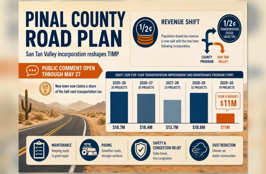
- A draft development impact fee study is available for public review at santanvalley.gov. A public hearing on adopting the study is set for June 3, 2026.
SAN TAN VALLEY, AZ — On April 1, 2026, the San Tan Valley Town Council heard a presentation on transportation improvements and funding from Chris Wanamaker, who was transitioning from his role as Pinal County Engineer to become San Tan Valley’s new Public Works Director. The presentation covered roads, development, growth, what the town can require of developers, and how infrastructure improvements are funded. No council action was taken.
Why Road Improvements Have Not Kept Up with Growth in San Tan Valley
Several causes were identified during the presentation.
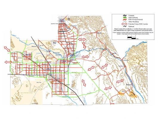
The county’s regional transportation plan dates to 2008 — nearly 20 years old. It covered only major arterial roadways on a two-mile grid at a county-wide scale, leaving out many of the roads residents use daily. Wanamaker noted the plan lacked sufficient detail and that adherence to it was inconsistently applied.
“The impact fees that are in place are about 50% of what they probably should have been,” Wanamaker said. “That was just the decision the county made at the time. And that’s what they are right now. So we haven’t collected enough money to actually cover the true impact of growth.”
In some cases, development agreements may have resulted in reduced fees or no fees at all. “There are things out there, like development agreements, for example, that the county has entered into with developers that have limited the amount of fees they pay or perhaps made it so they don’t pay any fees,” Wanamaker told the council. “There are developments that have not paid impact fees because they made these agreements with the county. And they’re still in effect.”
Vice Mayor Tyler Hudgins asked: “You’re saying there’s some really bad development agreements that were made from the county that have put us in some of this position?”
“Yeah,” Wanamaker said. “These development agreements are legally binding and run with the land.”
The presentation also cited abandonment of rights-of-way and lack of dedication and preservation for planned future minor arterial and major collector roadways.
Councilmember Daniel Oakes summarized his understanding of the planning failure: “As a town or as a municipality, you have to plan well enough to know what that amount is — because what we see in San Tan Valley is we’re 10 years behind on when developments get in, when we get to widen a road and get a stoplight.” Wanamaker agreed.
What “Growth Pays for Growth” Means
In Arizona, “Growth Pays for Growth” is a growth management philosophy under which new development is expected to pay for the infrastructure it requires, so that existing residents do not bear those costs.
“The primary goal of this kind of growth management philosophy is to ensure that development does not result in higher costs for existing residents,” Wanamaker said. “We want the new development coming in to pay for what they’re creating. But that doesn’t always work that way.”
What the Town Can — and Cannot — Require of Developers
Four U.S. Supreme Court cases establish the legal limits on what a town can require of a developer — Nollan v. California Coastal Commission (1987), Dolan v. City of Tigard (1994), Koontz v. St. Johns River Water District (2013), and Sheetz v. County of El Dorado (2024). Together, these cases require that any requirement placed on a developer must have a direct connection to the development’s impact and must be roughly proportional to that impact.
“If the development is adding a thousand more cars to the road, the improvements to the road must only be to accommodate those extra thousand cars,” Wanamaker said. “If you try to ask or require things beyond that, then you’re no longer proportional.”
Wanamaker introduced the most recent case — Sheetz v. County of El Dorado — and Billingsley elaborated on why it is of particular concern. According to Billingsley, a California county charged a fee to a man bringing a mobile home onto his lot. Other houses on the street had been built without being charged a fee, but when this man came in to develop his lot, the county charged him a fee to expand the regional route. The county did not have a study establishing the connection between the fee and the impact of his specific development. The case went to the U.S. Supreme Court and the county lost. The ruling reinforced that impact fees must be supported by a study establishing a clear connection between the fee and the actual impact of the development. Without one, fees can be successfully challenged in court. “The entire state of Arizona, and it should be the entire nation, is very concerned,” Billingsley said. Billingsley also noted that the town may need to purchase right-of-way for regional routes at fair market value rather than requiring it from developers. “The town, the county has to buy that additional right-of-way at fair market value because you cannot ask for that from the developer,” he said.
“There’s the impact fees, which pay for those regional improvements,” Wanamaker said, “and then the traffic impact analysis is what establishes the proportionality and essential nexus for those actual improvements that they will construct with their subdivision.”
What an Impact Fee Is and How It Is Calculated
An impact fee is a per-home charge collected from a developer during the building permit process, before a certificate of occupancy is issued.
“When you calculate the impact fee, you have to look at what is the projected growth and what are the roads that are gonna be needed to support that growth. And then what is the actual cost of building those roads?” Wanamaker said. “You end up with a per-home fee that is then used to build those roads.”
“You can’t collect development impact fees on traffic that’s already there,” Billingsley said. “We have to come up with the funds to pay for the existing congestion because we can’t ask the developers for that.”
“It’s paid every time a home is permitted,” Wanamaker said. “It could be $5,000 or $10,000 or whatever the fee is per home. That doesn’t get you a road. So you need to let that accumulate — up to several million dollars — to then be able to actually build something. So you could effectively have a subdivision completed, people moved in, with no road to get there because you don’t have the money yet.”
The Role of the Infrastructure Improvement Plan
The Infrastructure Improvement Plan (IIP) identifies the road projects needed to serve projected growth, along with their estimated costs. It establishes the current level of service on existing roads, calculates improvement costs per unit of new development, estimates revenue based on growth projections, and produces a ten-year project list. Billingsley said that after the Sheetz ruling, the town’s attorneys advised: “Have your DIF [development impact fee] study done well, include all the projects that are necessary in terms of regional improvements, justify that through the IIP. That’s your best protection.”
The town’s draft development impact fee study — which includes the IIP for transportation — was published on April 2, 2026 at santanvalley.gov.
Bonding and Impact Fee Revenue
Councilmember Oakes raised the question of whether the town could borrow money to build roads today and repay the debt as impact fees come in from future home permits.
Town Manager Billingsley explained that impact fees are not typically used to support bonds because they depend entirely on how many homes are built — and that can stop at any time. “The challenge with development impact fees is the market goes like this,” he said, referencing the 2008–2010 housing collapse as an example, when construction came to a near standstill. “You cannot properly determine what the likely fees received are.”
Billingsley noted that other revenue sources — including highway user funds, vehicle license tax, and construction sales tax — are typically used by cities, towns, and counties to back bonds because they are more stable and predictable.
Fees Collected by the County Before Incorporation
Before San Tan Valley incorporated, Pinal County collected development impact fees within the area. State law requires those fees to be spent in the designated region for which they were collected. Funds not spent within ten years of receipt must be refunded.
Questions remain about how those funds will be administered after July 1, 2026, when the transition from county administration occurs. “Those are some unanswered questions we still gotta work on,” Wanamaker said. Discussions between the town and county are ongoing.
Funding for Existing Road Problems
For roads that are already congested, the presentation identified grants, sales tax, and available current funds as sources of revenue.
“There’s a lot of grants out there available for roadway improvements. There’s a lot of money available through MAG, through ADOT, through Federal Highways,” Wanamaker said. “And now that we’re a town and now we have a voice, we’re gonna be able to get grants a lot easier than what the county has been able to do.”
Mayor Schnepf said: “Our current issues that we have right now — sounds like a lot of the funding will come from grants, from sales tax that will come out of the general fund that we can move over into the transportation side of it.”
Most grants require an approved transportation plan before a project qualifies. “One of the first questions that the agencies will ask when you apply for a grant is, ‘Is this project on your five-year plan? Is it on a transportation plan?’ And if you say no, you’re not gonna get the money,” Wanamaker said.
Hunt Highway and Gantzell Road: Widening Constraints
Certain road segments in San Tan Valley cannot be widened without acquiring property from current owners or negotiating with utility easement holders.
Hunt Highway: Widening to its ultimate planned seven-lane configuration “would require eminent domain and condemnation of property. And in some areas it may require relocating the families or whoever lives there,” Wanamaker said. “That’s not something the county wanted to do. We never wanted to relocate people and move homes and take property like that.”
Mayor Schnepf said: “We have areas where that’s the only way it’s gonna have to be to widen some of these sections. Gantzell has parts on it. Hunt Highway — where you just talked about that.”
Billingsley directed residents to the federal law governing condemnation: “If anybody wants to learn about the condemnation process and the requirements from the federal government, take a look at a document called the Uniform Act. The Uniform Act is the federal law that controls how condemnation occurs.” He noted the process involves more than paying fair market value and includes an extensive legal process.
Wanamaker described a prior condemnation during a flood control project in Queen Valley: “We had to pay for their new place of residence. We had to pay relocation costs. And honestly, we went above and beyond to make them whole — because it’s what we needed to do.” He said the resident worked with the county, received a comparable replacement property, relocation costs, and compensation for impacts to their daily life.
Gantzell Road: The Western Area Power Administration (WAPA) holds easements along that corridor that limit the town’s ability to widen the road on that side. “There would be probably years-long negotiations with them to enter into some sort of agreement,” Wanamaker said. “I don’t even know if they would allow a widening within their easement. It’s something that I tried to do when I was at the county, but we didn’t really get anywhere.”
Billingsley noted that relocating a single WAPA pole cost approximately one million dollars around 2010–2011, and that cost has increased since then. Mayor Schnepf noted there are many poles along the corridor.
Widening to the opposite side of Gantzell would involve the same condemnation considerations. Wanamaker noted that building a new road elsewhere may be more cost-effective in some cases and said the transportation plan will analyze those alternatives.
Development Moratoriums
Residents and council members have raised the question of whether the town can pause new development until roads catch up. Wanamaker addressed the issue directly.
State law provides a process for development moratoriums under ARS § 9-463.06, but the criteria are specific. A municipality must demonstrate a public safety issue with hard evidence, hold public hearings, and have a plan to address the problem. A moratorium cannot override existing development agreements or vested property rights. The maximum duration is 120 days, with a possible 120-day extension.
“If you did a moratorium, I don’t think it would do much and I think you’d open yourself up for legal challenges,” Wanamaker said.
Stopping permit issuance is also constrained by the U.S. Constitution’s Fifth Amendment takings clause. If a municipality prevents a property owner from exercising their property rights, it may be required to compensate the owner. “Arizona’s a very pro-property rights state,” Wanamaker said. “It would be very challenging if you tried to do something like that.”
The Transportation Plan and General Plan
San Tan Valley does not currently have a comprehensive, detailed transportation plan. The existing plan was adopted in 2008 and covers only major arterials at a county-wide scale. A new plan is intended to precede the town’s general plan.
“The transportation plan is gonna be essential for setting the town in the right direction for not only prioritizing what roads do we do first, where should we focus our money, but also getting those grants,” Wanamaker said.
The process will involve traffic modeling, coordination with MAG, CAG, neighboring jurisdictions, and state agencies, along with public engagement. The process is estimated to take at least 12 months.
Impact Fee Study Open for Public Review
The draft development impact fee study is available for public review at santanvalley.gov. A public hearing on adopting the study is scheduled for June 3, 2026. Wanamaker joins town staff on Monday, April 6, 2026. Billingsley said he and Wanamaker plan to begin identifying near-term improvements using available funds, while the start of the formal transportation plan process will depend in part on the timing of an ADOT grant application.