SAN TAN VALLEY, AZ — San Tan Valley has taken the first step toward joining the National Flood Insurance Program (NFIP). The Town Council approved participation at its March 18, 2026 meeting. Previously, some residents held NFIP flood insurance policies while the area was still unincorporated. With incorporation, continued access required the town to establish its own NFIP membership, according to Town Manager Brent Billingsley. A recent county study identified 222 structures in San Tan Valley at direct flood risk — residents can view the affected areas. Once accepted, all property owners will be able to purchase coverage through private agents at federally subsidized rates — generally lower than what the private market offers. The cost to the town is nothing beyond staff time. Property taxes already fund the Pinal County Flood Control District, which will administer the program on the town’s behalf.
What This Means for San Tan Valley Residents
Before this vote, the town was not a participating NFIP community. As a result, residents could not purchase NFIP-backed flood insurance through the town’s membership. Some residents held existing policies from when the area was unincorporated, but going forward, eligibility is tied to the town’s status as a participating community.
Town Manager Brent Billingsley explained that residents do not need to call the town, the county, or FEMA to buy a policy. Instead, they contact their existing insurance agent. “If you’re with American Family, you can go to your American Family agent and say, ‘Hey, I want to get flood insurance for my property,'” he said. In response to a question from Mayor Schnepf about how agents would know the town’s membership status, Billingsley added: “They will know if you’re in a flood hazard area or not. They’ll know the risk profile for here and then it’s a simple table — they go and look at the table and it’s a set rate.”
Billingsley called the NFIP rate “way cheaper” because “it’s federally subsidized.” Councilmember Rupert Wolfert, who held an NFIP policy when the area was still unincorporated, noted that coverage can run around $200 per year depending on home size, for approximately $20,000 worth of protection. Billingsley noted that figure applies to properties outside a mapped floodplain — rates are significantly higher for those within one.
However, Billingsley cautioned that if a property later gets remapped into a floodplain, rates increase dramatically. “If you have it, and then your property got remapped and put in a floodplain, you get to keep your same rate,” he said. “If your neighbor wants to join, they’re gonna pay more than 10 times” as much for the same coverage.
According to FEMA program materials presented at the meeting, there is also a 30-day waiting period between submitting a flood insurance application and the policy taking effect.
Who Manages Flood Control — and Who It Covers
Billingsley confirmed that the county administers floodplain management for most communities in Pinal County. The exceptions are Maricopa, Casa Grande, and Apache Junction, which manage their own programs independently.
Billingsley noted that cities managing their own programs typically want direct control over their own records and floodplain decisions. He said that deferring to the county gives San Tan Valley access to professionals whose primary focus is flood control. “It gave me a peace of mind to know that the flood control district, which is funded by the taxpayers, was making sure that all the Ts were crossed and Is were dotted,” he said.
Both Billingsley and Chris Wanamaker, who was approved as Public Works Director at the same meeting according to the Pinal Post, hold certifications as Certified Floodplain Managers. “We’re covered in terms of compliance,” Billingsley told the council.
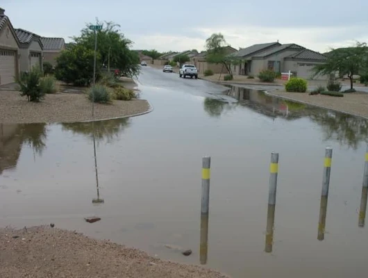
Flooding in Pinal County: Why This Matters Here
Billingsley pointed to a FEMA map showing Pinal County in the “known flood risk” category. Flooding here comes in two forms.
The first is riverine flooding. Billingsley cited the floods of 1983 and 1993 as examples, noting those events “washed out all the bridges in this part of Arizona, except for the bridge in Florence that crosses the river.” He added that the Attaway Bridge “washed away and had to be rebuilt” in 1993.
The second is sheet flooding. “When you get massive amounts of rain, it flows across the ground,” he explained. “As flat as we are, sheet flooding is an issue in this county.” He noted that large flood control structures visible in the desert — many owned and maintained by the Maricopa County Flood Control District even though they sit in Pinal County — exist specifically to protect cities in the East Valley from that risk.
Billingsley also referenced recent flooding in Globe and Miami as an example of how flood disasters unfold, noting his mother lives in Globe. “They’re going through the mitigation process to gain federal funds,” he said. “It’s not instantaneous. It takes years.”
Additionally, the town is currently engaged in two parallel regional flood studies. One, presented at a prior meeting by Josh Plum of the county, is a Pinal County-wide study. The second — the Mesa Queen Creek Area Drainage Master Plan — encompasses northern San Tan Valley and runs along the town’s boundary. Billingsley said it was “highly likely” the results would change existing floodplain boundaries. Mayor Schnepf added that the studies could result in some homes falling within a newly mapped floodplain.
What Is the National Flood Insurance Program?
The NFIP was created by Congress through the National Flood Insurance Act of 1968. According to FEMA materials presented at the meeting, the program was created to:
- Educate property owners, renters, and communities about flood risks
- Provide flood insurance to residents of participating communities
- Accelerate recovery from flood damage
- Reduce future flood losses through floodplain regulation
- Lower the personal and national costs of flood disasters
Participation is voluntary for communities. However, according to FEMA program materials, communities identified by FEMA as flood-prone that do not join within one year face federal sanctions within identified flood hazard areas, including loss of eligibility for federal development grants and loans, disaster assistance, and federal mortgage insurance or loan guarantees.
Benefits of Participation: What Billingsley Told the Council
Billingsley outlined several specific benefits to joining:
- Membership can make homeowners insurance cheaper overall, Billingsley said
- Properties built to or exceeding NFIP floodplain management standards incur at least 65% less flood damage on average
- Membership unlocks potential eligibility for federal mitigation funding for future flood control projects
- San Tan Valley can cooperate with FEMA on mapping and floodplain studies
What Flood Insurance Covers — and What It Does Not
Building Policy — Covered:
- The building and its foundation
- Permanently installed carpet over unfinished flooring
- Central air conditioners
- Ranges, cooking stoves, and ovens
- Furnaces
- Electrical systems
- Refrigerators
- Water heaters
Contents Policy — Covered:
- Furniture
- Electronics
- Area rugs
- Washers and dryers
- Food freezers and their contents
- Portable microwave ovens
- Artwork (up to $2,500)
Not Covered:
- Temporary housing during repairs
- Property located outside the insured building
- Financial losses from business interruption
- Currency, precious metals, stocks, and other valuables
- Cars and other vehicles
- Personal property kept in basements
- Finished basement improvements, couches, televisions, family photographs, and keepsakes kept in basements
How Residents Get Coverage
The town’s role is administrative and regulatory. Resolution No. 2026-12 authorizes San Tan Valley to formally join the NFIP and designates the Town Manager to maintain flood-related records, including elevation certificates and floodproofing documentation for structures in flood hazard areas. Billingsley noted these records are audited about every five years.
Billingsley noted that purchasing directly through the federal government’s own NFIP Direct program is not recommended. He said many of those staff are no longer employed due to federal cutbacks, and getting through that channel would be difficult.
Flood Insurance vs. Disaster Assistance: A Critical Distinction
Billingsley emphasized that flood insurance and federal disaster assistance are not the same thing. Disaster assistance requires separate declarations of emergency from the mayor, the governor, and the federal government. It is not guaranteed, and even when available, the primary form it takes is an interest-bearing loan, not a grant. According to FEMA materials presented at the meeting, the maximum possible payout to make a home safe and habitable is $42,500.
By contrast, flood insurance claims are paid whether or not a presidential disaster is declared. FEMA materials cited an average claim payment of $78,592 following Hurricane Ian.
“I wouldn’t plan on” disaster assistance bailing you out, Billingsley told the council, “because a lot of things have to go right.”
Additional Council Remarks
Vice Mayor Tyler Hudgins noted that last year’s rain caused flood damage on properties in San Tan Valley. He requested that the town add a dedicated flooding page to its website, including links to flood insurance resources and the SBA disaster assistance program, which he had previously asked to be added to the town’s resources page. “Bringing that awareness to our community would be really important,” he said.
Mayor Schnepf added that the ongoing flood studies make the NFIP decision particularly timely. “It will happen,” he said of a significant flood event. “It’s not a matter of if, it’s when.”
Council Action and What Comes Next
The council approved both Resolution No. 2026-12 and Ordinance No. 2026-01, with no opposition recorded. The town must now submit its application to FEMA and the Arizona Department of Water Resources. Once accepted, all San Tan Valley residents will be able to purchase NFIP-backed flood insurance through their private insurance agents under the town’s own membership. Two active regional flood studies are also underway, which Billingsley said could result in updated floodplain maps affecting properties across northern San Tan Valley.