Largest Solar Development Yet Sparks Concerns Over Wildlife, Roads, and County Strategy
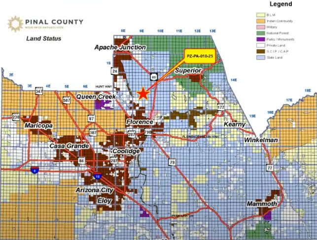
The Pinal County Planning and Zoning Commission held a work session on July 17, 2025, to discuss the Silver King Solar and Storage project, a comprehensive plan amendment that would create the largest solar development in county history. The commission reviewed more than 14,300 acres of energy-related development proposals that day, including the Silver King Solar and Storage project, additional solar farms, and an energy generation and technology campus with unspecified solar capacity. The commission took no action during the work session, as the meeting served only as an informational discussion.
Project Details and Scope
Silver King Solar LLC, a subsidiary of Arevia Power LLC, seeks to redesignate 8,891 acres from Moderate Low Density Residential to Green Energy Production for a photovoltaic solar power plant. The project encompasses 12,915 total gross acres of Arizona State Trust Lands, which are owned by the Arizona State Land Department and would be leased to the applicant, making it unprecedented in size for Pinal County.
“This is the largest one that has been proposed to date,” said Senior Planner Sangeeta Deokar.
Vice-Chairman Robert Klob emphasized the project’s massive scale: “9,000 acres is a big piece of dirt. Some of the ones that have really generated a lot of pushback are 1,500, 2,000 acres. I can only imagine where this one is going.”
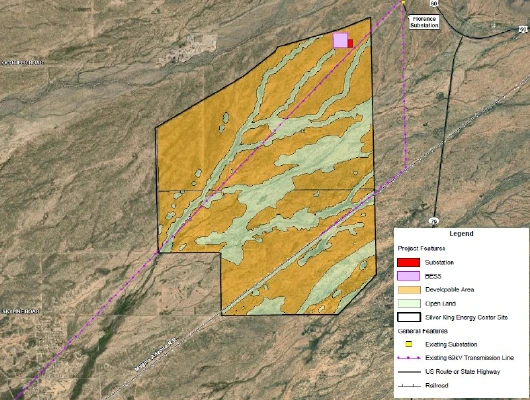
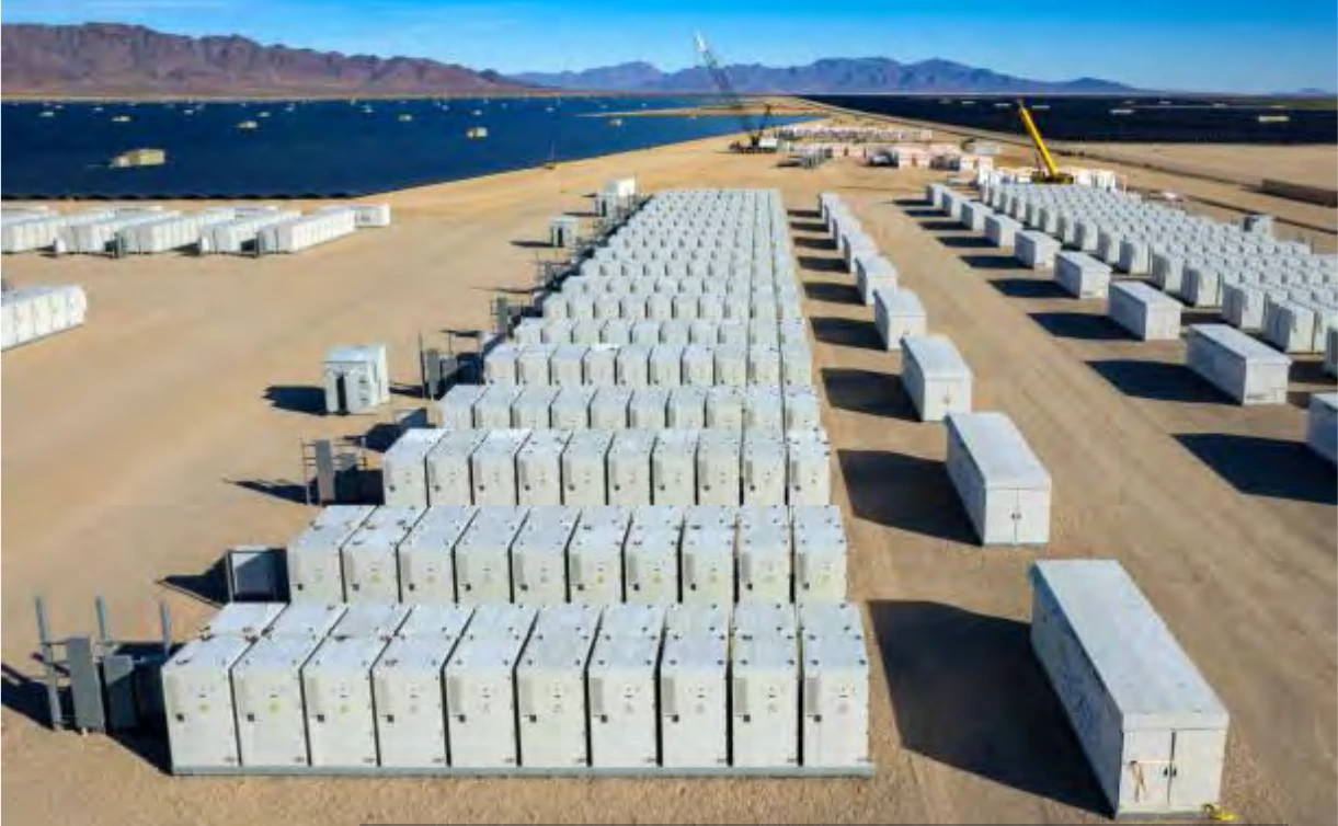
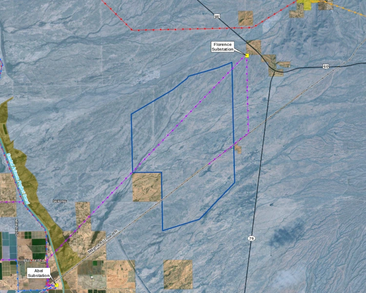
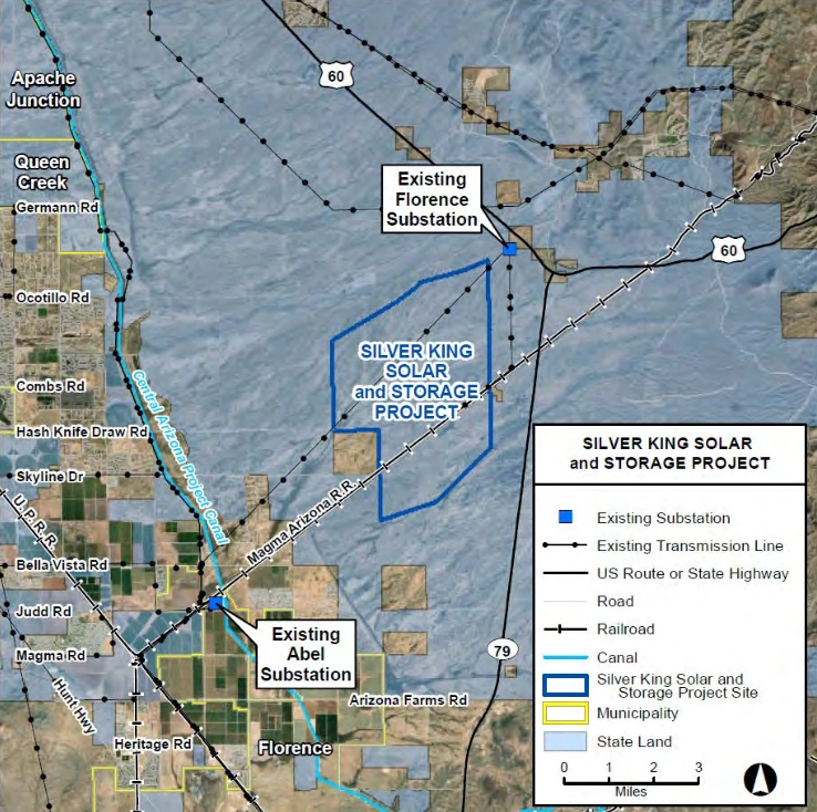
The facility would generate up to 1,100 megawatts of solar power and include an up-to-1,100 MW battery storage capacity system. The project would also feature a new substation and a generation tie-line (transmission line connecting the solar plant to the grid) that would parallel an existing 69,000-volt transmission line running between the Florence Junction and Abel substations.
The project is estimated to support up to 300 construction jobs annually over a 4-5 year build-out period.
If the comprehensive plan amendment is approved, the applicant would then submit a separate rezoning application to change the parcels from General Rural (GR) to Industrial Zoning District (I-3).
Location and Surrounding Area
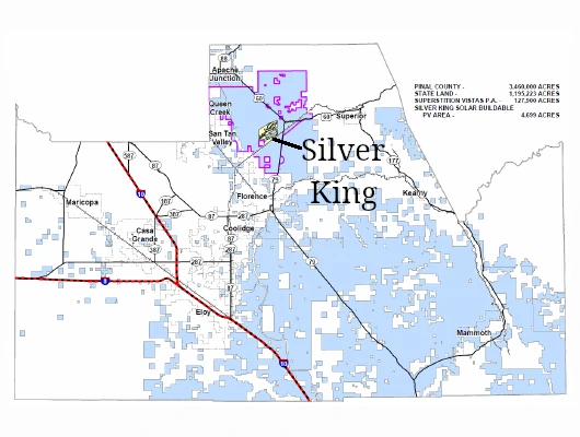
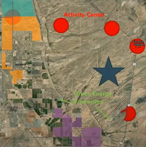
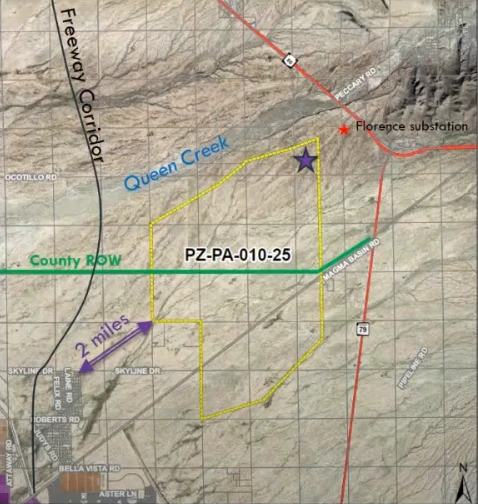
The project sits southwest of Florence Junction, south of Queen Creek Wash, and northeast of the town of Florence, five miles north of East Arizona Farms Road. The development area lies west of the intersection of State Highways 60 and 79.
The battery energy storage system and a new project substation will be located in the northeast corner of the project area, near the existing Florence Junction Substation. The nearest residential areas sit approximately 1.7 miles southwest of the project area. The property is zoned General Rural, with portions to the southwest designated as CB-3.
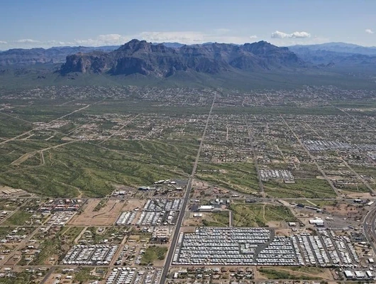
A proposed freeway corridor runs along the western boundary of the project area. The project lies within the broader Superstition Vistas growth area, a regional planned development of approximately 275 square miles originally proposed in the early 2000s. The project area is near conceptual activity centers along the future State Route 505 corridor (a.k.a. north-south corridor), located approximately 2 miles from the project site, which were envisioned in earlier planning documents as potentially supporting up to 11,000 residents, though development remains speculative and the area lacks infrastructure such as water access. The area includes existing county right-of-way crossing the project from west to east, which developers will need to address with county engineering during future planning phases.
Growing Solar Pipeline in Pinal County
The Silver King project represents just one of several major solar developments seeking approval in Pinal County. Three other significant solar projects appeared on the same work session agenda:
Silver Reef Solar requests re-designation of 801 acres from Very Low Density Residential to Green Energy Production for a 150-megawatt photovoltaic solar facility with a 200-megawatt battery storage system. This project would be located 6.5 miles southwest of Casa Grande, south of Interstate 8.
Griffin Energy seeks to re-designate 2,685 acres from Moderate Low Density Residential and Proposed Open Space to Green Energy Production, General Public Facilities/Services, and Proposed Open Space. This utility-scale solar facility with battery storage would include a gas-fired power plant, positioned between the Santa Rosa Wash and Green Wash on both sides of Interstate 8.
W Holdings requests redesignation of 2,495 acres from Moderate Low Density Residential to Employment for a large-scale Energy Generation and Technology Campus. This project would be located approximately eight miles south and east of Maricopa, south of the Ak Chin Indian Community.
Commissioner Concerns About Strategy and Wildlife
Commissioner Gary Pranzo expressed broader concerns about the county’s approach to solar development. “I’m only here short-term… but I get the general feeling that Pinal County is being peppered with solar. And the presentations are very professional, both by the county and by the owner. My problem is that I don’t know if they’re strategic. I don’t see the engineering other than what’s presented by the owner.”
Pranzo continued: “I understand the build-out along Interstate 8 seems to be growing. We get more and more applications, whether they’re gas fired or solar or whatever, but I don’t see any strategy to this. So, before I can feel comfortable, I would like to see the county either bring APS in or some kind of a strategy to it where I feel comfortable that the land use is living up to its full potential in terms of providing power.”
Commissioner Karen Mooney raised significant environmental concerns, particularly regarding wildlife displacement. The project area contains substantial riparian habitat with numerous washes and corridors identified by Arizona Game and Fish as important wildlife movement areas.
“Where are they gonna go? We keep just chopping everything up… That’s a ton of wildlife and you’re supposed to build them a little corridor to, ‘This is your safe space to get to the next place,’ and it’s just becoming very, very sad to see all of this wildlife being pushed out and eventually there’ll be none,” Mooney said.
She concluded: “This particular project has too many negatives for me.”
Transportation and Infrastructure Challenges
Commissioners expressed concerns about road access and future transportation needs in the growing area. The project area sits in a zone expected to see significant development, with roads such as Ocotillo and Skyline, which serve as key east-west routes for regional connectivity north of Florence, potentially providing crucial east-west access.
One commissioner noted: “The proposal right now would be county road going SR 79?” when discussing access routes through the property.
County staff explained that developers hadn’t initially known about existing county right-of-way crossing their property but would need to work with county engineering to determine how to accommodate the road while developing around it.
The discussion highlighted concerns about maintaining east-west connectivity as large solar projects potentially block traditional traffic patterns. “You have the freeway corridor going there, so where’s the access east-west? Are they gonna be closed off because of this project?” one commissioner asked.
Regional Multi-Use Trail Requirements
The project area includes a planned regional multi-use trail corridor associated with Queen Creek Wash, portions of which transect the project site. According to county code, developers bear responsibility for constructing the trail with decomposed granite pedestrian paths, appropriate signage, and dedicating the corridor to the county. However, since the project is on Arizona State Land Department land, full trail dedication may not be feasible, and the developer has committed to working with the County and ASLD on an appropriate arrangement.
The trail would connect to existing and planned recreational infrastructure, providing public access while preserving wildlife movement corridors along the wash system that traverses the project area.
Future Timeline and Process
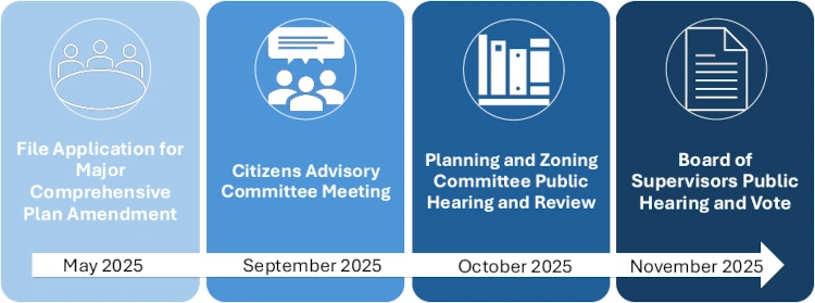
The project faces an extensive review process involving multiple public hearings and work sessions. Senior Planner Sangeeta Deokar outlined the timeline: “In total, five sessions. Two work sessions and three public hearings.”
The process includes an initial Citizens Advisory Committee public hearing in September 2025, followed by a Planning and Zoning Committee public hearing in October 2025, and concluding with a Board of Supervisors public hearing and vote in November 2025. The Board of Supervisors will also hold their own informational work session as the second of two total work sessions before the formal public hearing process begins.
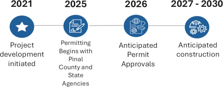
According to developer documents, if approved, the project would begin permitting in 2025-2026, with anticipated permit approvals in 2026 and construction expected to start in 2027 and continue through 2030. The operational lifespan of the project is anticipated to be approximately 35-40 years.
Given the project’s unprecedented size and the concerns raised by commissioners, the Silver King Solar project appears headed for intense public scrutiny and potential opposition as it moves through the county’s approval process over the coming months.