Casa Grande City Council unanimously approved a three-year contract with Cyvl Inc. on July 21, 2025, making it the first city in Arizona to use artificial intelligence-driven technology for comprehensive street pavement assessment. The contract totals $140,000, which includes $135,000 for services and a $5,000 city-controlled contingency, and will modernize how the city manages its approximately 355 paved centerline miles of roadway.
Council Decision and Scope
The council passed Resolution 5792 authorizing the contract with Cyvl Inc. to provide network-wide pavement and roadway data collection services for the city’s pavement management system. The unanimous vote followed a presentation by Engineering Technician Natalie Stephens and Public Works Director Kevin Louis.
“We’ll be the first city in Arizona to use this technology,” Stephens told the council. However, she noted that Cyvl “is currently doing the same type of work in many other states, so it’s pretty much nationwide.”
Pilot Program and Vendor Selection
According to internal communications, the Public Works Department had previously received a $150,000 quote from their traditional provider, IMS, for a conventional survey using specialized vehicles and equipment. However, Cyvl’s approach offered several advantages including the ability to inventory multiple asset types beyond pavement and the potential for more frequent data collection at a lower long-term cost.
The city conducted a pilot evaluation on Cottonwood Lane in April 2025 before committing to the full contract. The pilot project, which cost $4,999, demonstrated the technology’s effectiveness and its ability to support integration with the city’s Lucity software system.
“The service worked perfectly. No issues. It was seamless,” Stephens reported about the pilot results.
Data Ownership and Management
According to the draft contract, all project results, including imagery, condition data, and reports, belong to the city for internal governmental use. However, Cyvl retains ownership of its background technology, software, algorithms, sensors, and methodologies.
The city receives a perpetual, royalty-free license to use the collected data. Cyvl processes the raw data collected by city vehicles and provides the analysis through their platform.
About Cyvl Inc.
Cyvl Inc. is a Somerville, Massachusetts-based infrastructure intelligence platform that uses AI, LiDAR, and 360-degree imagery to automate pavement and sidewalk assessments. The company’s stated mission is to accelerate the future of infrastructure by building tools to make roads, sidewalks, and cities more efficient to plan, build, and maintain.
Cyvl’s platform aims to help cities map, assess, and manage their streetscapes while providing better visibility for infrastructure planning and maintenance decisions.
Technology and Services
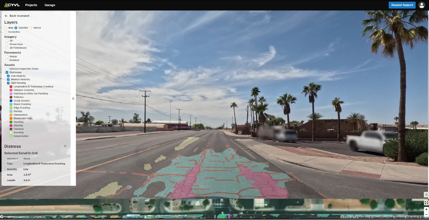
The new system represents a significant departure from traditional pavement assessment methods. Instead of hiring consulting firms with large vans equipped with specialized equipment, Casa Grande will use vehicle-mounted sensors attached to a city vehicle.
“Now it’s this small piece of equipment that we strap on the top of the vehicle and basically just drive the city streets,” Louis explained to the council. “It’s very impressive, the detailed information that is produced. But more importantly, we’ve got that video recording of each deficiency out there so we can really look at it and evaluate what is the best method to attack trying to get these pavement conditions up to our target.”
Cyvl provides vehicle-mounted sensors that will be installed on a city vehicle. City staff will collect data by driving local streets with the sensor-equipped vehicle. The company then processes the collected data and provides analysis through their platform.
Data Collection and Analysis
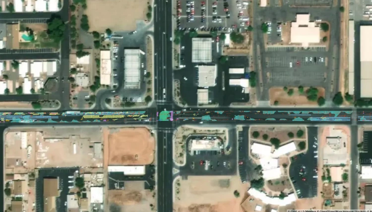
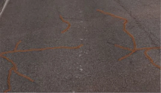
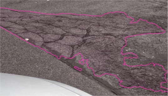
The system will evaluate various types of pavement distresses including alligator cracking, potholes, and rutting. Beyond pavement conditions, the technology will inventory other street assets such as signage, sidewalks, streetlights, manholes, and other key infrastructure elements. Some sample detection presented by Cyvl to the council are shown below.
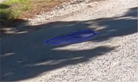
Potholes
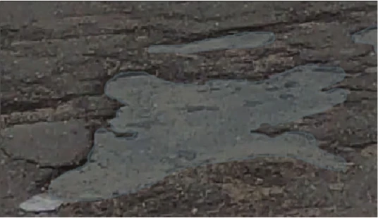
Delamination
Crack sealant
Alligator Cracking
The last comprehensive data collection occurred seven years ago. Louis emphasized the importance of regular updates, stating that cities should “update your model” every five to seven years, comparing it to “calibrating any type of piece of equipment.”
The collected information feeds into the city’s pavement management model, which uses ArcGIS software with a Lucity add-on. This system projects future roadway conditions and guides maintenance decisions. Public Works has used pavement index technology to manage their pavement maintenance program for just over 18 years, according to Louis, who noted the department’s success in maintaining road quality compared to neighboring cities.
Pavement Condition Index System
The collected data enables the city’s pavement management system to calculate a Pavement Condition Index (PCI), a numerical rating from 0 to 100 that indicates pavement condition. According to Louis, “100 being a perfect road, 0 being no road at all.” The city targets maintaining an average Pavement Condition Index (PCI) of 75 across all pavements.
According to Louis, a brand new road starts at 100 on the PCI index but typically drops to around 90 within a year due to Arizona’s harsh climate conditions. He explained that the detailed pavement data helps validate that the city’s preventive maintenance program is working to extend the lifespan of asphalt surfaces.
Cost Structure and Equipment Access
The three-year contract structure requires a $135,000 upfront payment that covers all three years of service, with no additional annual fees. This prepayment approach provided the city with a $16,000 discount according to the service agreement. The city also approved a $5,000 contingency for a total authorization of $140,000.
Beyond the initial comprehensive assessment, the city can access Cyvl’s equipment for additional data collection projects. “We can rent the equipment whenever we want to,” Stephens explained. “We just tell them we want to scan more roadways. They send us the equipment down, and we install it and scan it. And they take the data and process it.”
The service agreement indicates that the city will receive 12,000 credits per year in years two and three, which may be applied toward on-demand projects, Cyvl Support, and Cyvl Platform services. This arrangement allows the city to conduct updates more frequently than the traditional five-year cycle.
Targeted Maintenance Strategy
The detailed data will enable targeted maintenance approaches. The system provides visual representations of pavement conditions and allows staff to work with asphalt companies to develop specific treatment strategies for identified problems.
“We can sit down with our asphalt companies that come in to provide us with our quotes, and they can provide us with estimates on what they would do, or ideas what they would do to take care of those pavement conditions,” Louis said.
Implementation Timeline
According to the service documents, the contract term is scheduled to begin in early July 2025 and run for three years. The original action plan outlined citywide data collection for August 2025, with processed data posted on the Cyvl platform by September 2025. However, the actual implementation timeline may have been adjusted following the July council approval.
With Casa Grande’s approval, the city joins a network of municipalities using AI-driven infrastructure assessment technology. The three-year contract positions Casa Grande to conduct more frequent pavement assessments than the traditional five-year cycle, providing updated data for infrastructure planning and maintenance decisions in a rapidly growing city.