Key Points
- San Tan Valley is planning a new 3,239-acre urban core.
- The project will create a future downtown for the town.
- Residents can expect jobs, shopping, and diverse housing options.
- Cities rely on sales tax and state-shared revenues—so commercial development is necessary.
- Town leaders say the site is essential for long-term financial stability.
- Development is expected to unfold over several decades.
- A flexible plan allows uses to shift as the market changes.
- A potential commuter rail station could be located in the core.
- State land will be sold in phases as demand grows.
- Existing county plans will guide decisions until the town adopts its own general plan.
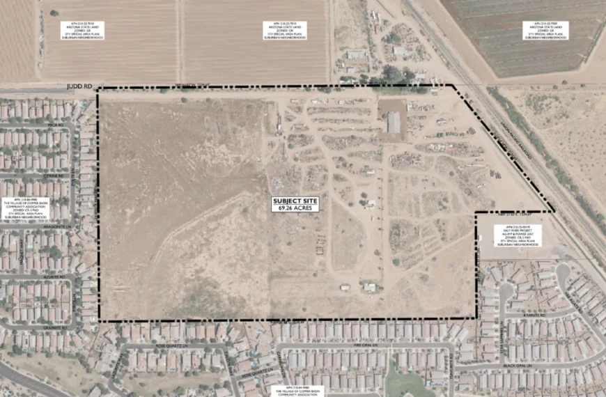
Brent Billingsley outlined a strategic development vision during a December 3, 2025, council presentation. Earlier in the same meeting, he was appointed as San Tan Valley’s first town manager. He explained how existing planning documents will guide growth. His focus centered on the San Tan Valley Urban Core, a 3,239-acre project that officials call the most important property for the town’s financial future.
The presentation combined material from the 2018 Special Area Plan with material prepared for this year’s urban core approvals—a comprehensive plan amendment and rezoning. Together, these documents give San Tan Valley a foundation for land use decisions while it develops its own general plan.
What This Means for Residents
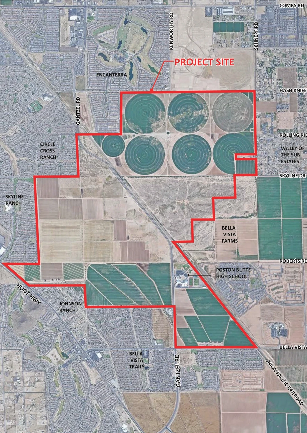
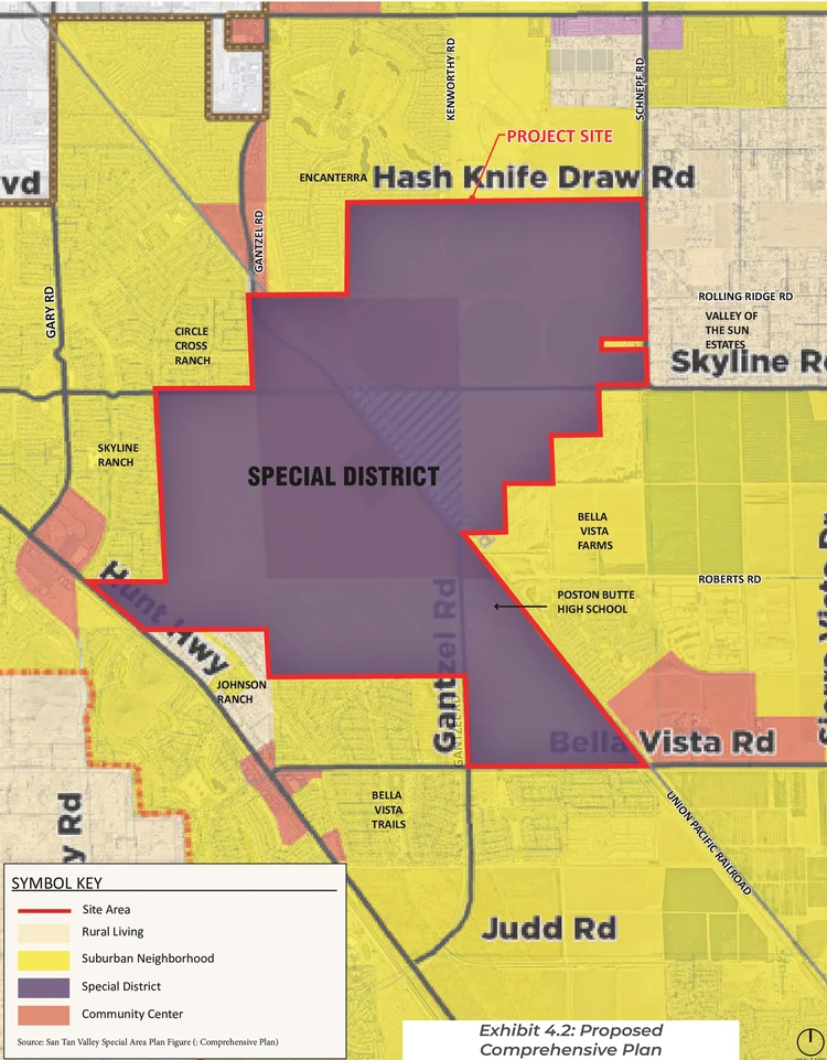
Residents can expect a future downtown center with jobs, commercial development, and diverse housing options. The urban core transformed 3239 acres of state-owned farmland into a mixed-use development zone. This land sits in the heart of San Tan Valley—north of Bella Vista Road, south of Hash Knife Draw Road, and east of Hunt Highway.

Vice Mayor Tyler Hudgins emphasized the property’s importance. “I do not believe we would be incorporated today if the county and the state didn’t work together to get this piece of property within our boundaries,” he said. He added that it “is the strategically most important piece of property” the town has for its future. Mayor Daren Schnepf agreed, saying “being able to advance the work that needs to be done here is super important.”
At the February approval meeting, Pinal County Planning Manager Harvey Krauss said development could span “possibly 20, 30, 40 years.” However, the framework is now in place to attract developers and generate revenue.
Why Revenue Matters
Billingsley addressed a fundamental challenge facing the new town: financial sustainability. Counties rely primarily on property tax, but cities depend on transaction privilege tax (TPT) and state-shared revenues—which require commercial activity.
“If you really want to be a financially stable city, you need to have jobs and you need to have commercial revenue,” Billingsley said. “And as you saw from the Comprehensive Plan and from the Special Area Plan, there’s not a lot of commercially or industrially zoned property in San Tan Valley, which is a concern going forward.”
This concern drove the creation of the urban core. “The whole idea of doing this large master plan community zoning case was to give San Tan Valley a future city center, a future opportunity for industrial, commercial, jobs growth,” Billingsley explained. The project also provides “opportunities for multi-use transportation as well as different types of residential with multiple densities.”
The Pinal County Board of Supervisors unanimously approved the project in February 2025. “We essentially had to meet a four-month timeline to do a major rezoning case and the normal process is six months,” Billingsley said. The expedited timeline was necessary to complete the rezoning before incorporation deadlines, allowing the property to be included within the town’s boundaries.
Understanding the Planning Framework
Billingsley distinguished between three key planning tools that will guide growth.
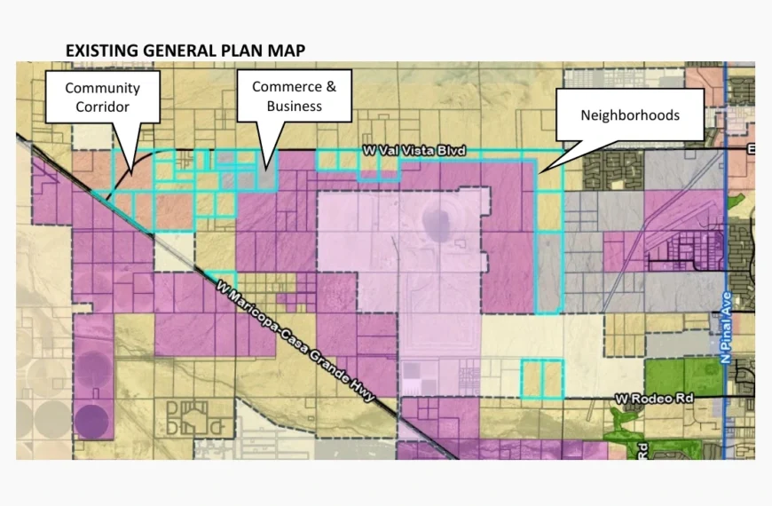
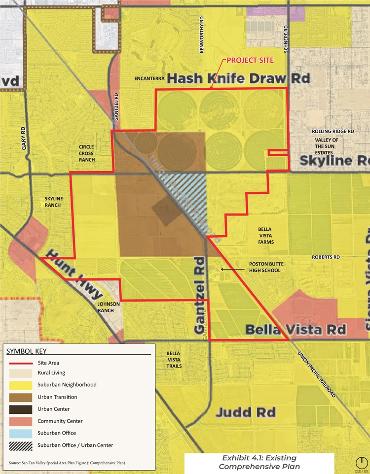
The Pinal County Comprehensive Plan is a policy document that has guided San Tan Valley’s growth while unincorporated. It designates general land use categories but does not regulate what gets built. Billingsley’s presentation slides noted challenges with the previous designation’s emphasis on low-density residential: it encourages sprawl, promotes auto-oriented design, increases traffic congestion, and makes infrastructure planning more difficult. The urban core’s new “Special District” designation—available only on state trust lands—allows a mix of compatible uses including housing, retail, employment, and open space.
Recent Special District approvals in Pinal County range from the North Copper Basin residential and commercial project—located in unincorporated Pinal County just outside San Tan Valley’s municipal boundary—to Project Ranger, a planned manufacturing facility near Florence that reports have linked to hypersonic missile production.
Zoning provides the specific regulations to implement the Comprehensive Plan’s vision. It determines what can actually be built on each parcel. The urban core’s zoning changed from General Rural (GR) to Large Master Plan Community (L-MPC). The county adopted this floating zoning district in 2021 as an alternative to conventional zoning. The zoning district requires at least 2,000 contiguous acres under single ownership or exclusive control. Projects must include multimodal transportation planning and direct access to major roadways. Importantly, this zoning allows developers to shift density and building intensity between different areas of the project—a key feature Billingsley highlighted.
The Special Area Plan sits between these two. According to Pinal County, its purpose is “to examine the unique issues, concerns, and needs of the San Tan Valley area to establish public policy and guidance for future growth.” It provides more localized guidance than the county-wide Comprehensive Plan. Michael Baker International assisted the county in developing the plan—the same firm that recently worked on a county-wide zoning code update that was withdrawn following public concerns.
Billingsley emphasized that the planning cupboard is not empty. “There are tools like the Special Area Plan, like the Comprehensive Plan, like the Routes of Regional Significance and Access Management Plan, the Pinal County Transportation Plan, that we can use as guiding documents as a new city before we have our own general plan,” he said.
Billingsley drew on his experience as Development Services Director in Maricopa from 2005 to 2012. That city incorporated on October 15, 2003. “In Maricopa, it took us two to three years to get to that point. And then we did the zoning code update about six years after incorporation. So, these things take time, but we have tools that we can use in the toolbox.”
How the Flexible Zoning Works
“The plan itself is very unique. This is kind of a cutting edge type of zoning case,” Billingsley said. “We’ve tried to follow the path of Apache Junction and Superstition Vistas, and what they did up in that area, and we even enhanced it further.”
He explained the difference from conventional approaches. “Instead of a traditional zoning case where you may have commercial, industrial, high density residential, low density residential, mixed use, this is a plan that sets up a series of development areas. And the beauty of this plan is, it’s not set based on one certain type of zoning. It can fluctuate. It can change.”
The plan sets maximum dwelling units and floor area ratios for commercial or industrial development. “But they can shift across boundaries,” Billingsley said.
“It’s very flexible. It’s innovative. It’s intended to make the land very marketable so that the State Land Department can sell it for highest and best value, which is their statutory requirement,” Billingsley said.
He added that developers also benefit. “Developers want flexibility. They want to understand what they can do. They want to understand how long it’s going to take. They want consistency in process. This gives them the ability to change over time based on what the market demands.”
Mayor Schnepf summarized the approach, asking Billingsley: “First come, first served? Whoever wants to buy state land first in there can move something around?” Billingsley confirmed. “That was the genius behind this,” Schnepf said.
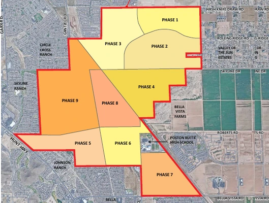
The Nine Development Areas
The urban core divides into nine distinct zones:
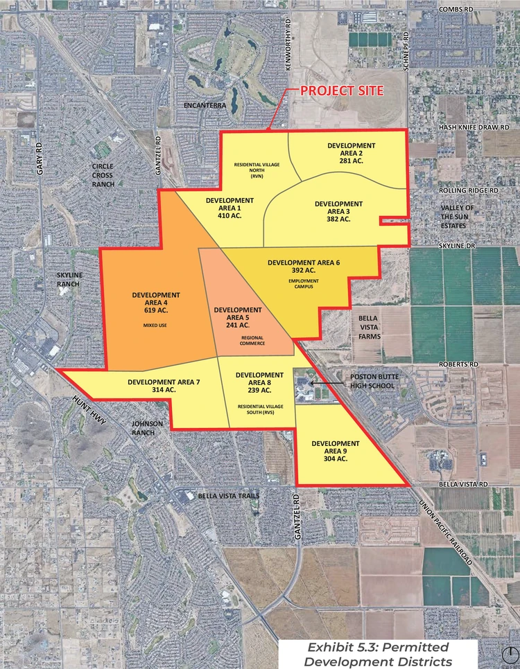
Development Areas 1 and 2 are shown as residential districts but could shift to commercial uses if developers bring those proposals first. Billingsley used these areas to illustrate how density shifts work: “Those are shown as a residential district, but if a commercial center were to be located within that area, that commercial can then be removed out of one of the other development areas, and then that residential density would then be replaced, say, in Area 4.”
Area 4 is the largest zone at 619 acres. It allows medium and high-density residential, multi-family, and commercial uses. Billingsley referenced it as a potential receiving area for transferred residential density.
Area 5 is the commercial core. This central zone could eventually house a future rail station and represents the heart of the planned downtown. It also permits office, industrial, and tech employment uses.
Area 6 is reserved for potential high-tech development. Billingsley noted it offers rail access and could attract “industries that are synergistic with LG,” referring to the LG Energy Solution battery manufacturing campus in Queen Creek. This area provides opportunity for job growth and economic development.
Areas 1, 2, 3, 7, 8, and 9 allow traditional low-density single-family residential. These surrounding zones provide transitions to existing neighborhoods.
The maximum caps serve infrastructure planning. “You have to limit it because you have to understand power, water, sewer, police, fire,” Billingsley explained. Planners need a basis for understanding required service levels.
Commuter Rail Possibilities
The presentation included discussion of passenger rail. A Phoenix-Tucson study is currently moving forward under the Arizona Department of Transportation. The Federal Railroad Administration approved ADOT’s submissions in June 2025 for the Corridor Identification and Development Program.
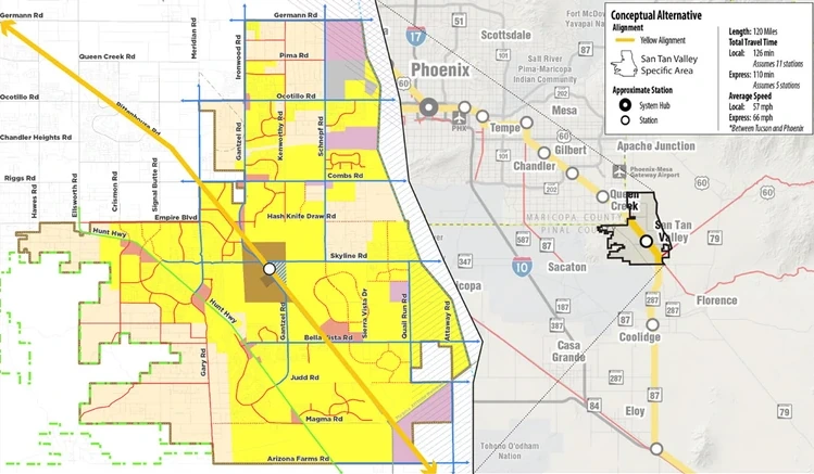
The planned route runs approximately 160 miles between Tucson and Buckeye. It would use existing Union Pacific Railroad tracks that pass through the area. Area 5 in the urban core is positioned to potentially accommodate a future station.
ADOT’s Service Development Plan, expected to take two to three years, will identify station locations based on travel data, technical feasibility, and access to jobs, schools, and airports.
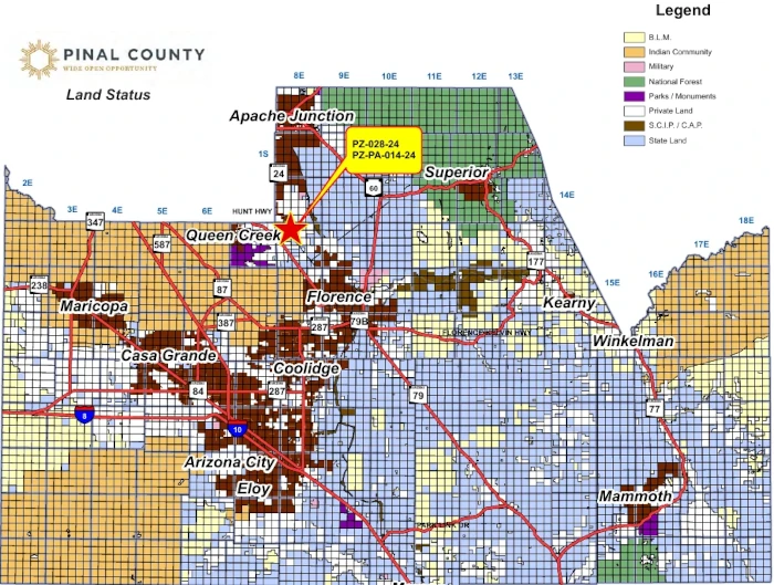
Study Area and Land Ownership
The San Tan Valley Special Area Plan covers 45,222 acres with the following ownership breakdown:
- Private: 31,642 acres (69.97%)
- State Trust: 12,911 acres (28.55%)
- Bureau of Land Management: 484 acres (1.07%)
- Bureau of Reclamation: 185 acres (0.41%)
The urban core encompasses 3,239 acres of state trust land.
Developer Interest Emerging
The flexible framework is already attracting attention. As Pinal County’s Community Development Director since February 2022, Billingsley was directly involved in developing the urban core project. He mentioned receiving phone calls after presenting at an American Planning Association event.
“I’ve received two phone calls after we made the presentation at APA saying, ‘Okay, we want to talk,'” he said. From the county perspective, he explained they told interested parties to wait for the election results. “You’re probably going to have to talk to San Tan Valley,” he advised them.
What Happens Next
The town will continue building its administrative capacity before the July 1, 2026, operational deadline. Under Arizona law, Pinal County must continue providing services—including law enforcement, street maintenance, and code enforcement—until that date or until the town assumes responsibility.
Meanwhile, the Arizona State Land Department will auction urban core parcels as market conditions allow. Each phase will require additional planning and approvals before construction begins. The L-MPC framework gives developers flexibility to respond to market conditions while staying within established limits.
Billingsley noted that developing a general plan typically takes two to three years. A zoning code update may follow about six years after incorporation. Until then, existing county planning documents will guide land use decisions for Arizona’s newest municipality.